
PLATE I
Early Antarctica appeared as the second publication of the 'Map Collectors' Circle,' which was founded by Tooley in 1963. Before discontinuing publication in 1975, the Circle issued 110 monographs. Early Antarctica later was included, unchanged, as an Addendum to Tooley's The Mapping of Australia and Antarctica, second revised edition (London: Holland Press, 1985).
I've long wanted to place this useful publication on the Antarctic Circle website but had been unable to determine who held the rights. Tooley is deceased, the Map Collectors' Circle is no more, likewise the Holland Press. I've consulted with mapsellers and have posted a query on "MapHist: E-mail discussion group on the history of cartography" and although there were responses, they did not lead me to the holder of the rights.
I have nonetheless gone ahead and included the paper below. If anyone can lead me to the holder of the rights, I would appreciate it. I will, of course, remove the paper if requested to do so by the holder of the rights.
—R. Stephenson
(27 December 2004)
THE South Pole has intrigued the mind of man for centuries and in recent years this interest has increased enormously. Many excellent accounts have been written on the exploration and discoveries in this area, but curiously enough the history of the early mapping of the region has been almost totally neglected. The catalogues of the British Museum and the Royal Geographical Society under the heading Antarctica list less than a dozen maps before 1840, and the more recent and excellent supplement to the Library of Congress Geographical Atlases by Miss Le Gear records 18 printed maps. All these libraries have of course far greater resources but no-one so far as I know has attempted to list them. It is not possible in the following short article to accomplish this, but an attempt has been made to shed a little more light on this unclassified material, to indicate lines along which a more exhaustive study could be made, and to encourage an interest in one of the most challenging areas of modern times.
The Geographical history of Antarctica is of ancient and venerable origin. Although the very earliest known maps occasionally referred to a land mass in the unknown South, the T O maps lack all such reference. The T O map, a simple circle divided into three compartments representing Europe, Asia and Africa, is constructed by placing a T within an O. This device coincides happily with early Christian teaching, the T representing the Cross spanning the world, and the three compartments, the three sons of Noah—Shem, Ham and Japheth. The earliest printed T O map (1482) is reproduced on the cover of this publication and has been chosen as the emblem of the Map Collectors' Circle.
Another simple form devised to represent the world was a circle divided by horizontal lines into sections Frigid, Temperate, Torrid, Temperate and Frigid. These were known as climatic maps. Elaborations of both forms were evolved with the passage of time, the southern segment representing Antarctica.
That there was land to the far north was known to the ancients, and that being so, the theory was advanced that there must be logically a land mass in the far south to counterbalance the globe. Further it was held that the equatorial or torrid belt in the climatic map became so hot towards its centre as to be uninhabitable and even impassable to man.
Pomponius Mela in the first and Macrobius in the fifth century both postulated a vast southern continent occupying half the globe.
The knowledge of the ancient world was summed up by Claudius Ptolemy in Alexandria about 150 A.D., who, in his design for a world map, landlocked the Indian Ocean. All these theories reflecting the whole weight of ancient thought favoured the existence of a great antarctic continent.
The early Christian church frowned upon a belief in the Antipodes, and finally declared it heresy. Geography for a time reverted to the old belief in a flat round world and maps of the wheel or T O type were the only ones approved.
The first great increase of knowledge came to the West with the travels of the Polos in the 13th century. Nicolo, Maffeo, and Marco Polo by their travels and reports proved the existence of lands beyond the limits of the ancient world, Marco Polo in particular reporting lands of great richness in the far south that he named Beach, Lucach and Maletur.
The revival of learning, the rounding of Africa and, above all, the discovery of America led inquiring minds to turn eagerly to the south. The classics were translated and the tradition of a great south land again took hold of men's minds both for intellectual and utilitarian motives.
Amerigo Vespucci reported that on a voyage to Brasil he was driven by storm 500 miles to the south east where he sighted land which was named Terra da vista or Land Seen. Two unidentified Dutch vessels attempting the same journey a few years later had a similar experience and named their landfall "Pressillgtlandt."
The motive behind 16th century exploration was the desire to reach the Indies, the repository of wealth from ancient times, and deliberate attempts were made to round South America with this end in view. Once accomplished, however, by Magellan in 1520, further exploration towards the south was for a long time afterwards accidental, owing to ships being blown off course by the prevailing bad weather. One famous voyage was that of Sir Francis Drake in 1578. Driven by gales to 57° south, on the wind moderating, he turned north and encountered some islands which he named in honour of his queen, the "Elizabethides." These were almost certainly the Tierra del Fuego group and are most charmingly shown on a map by Hondius published by Le Clerc in 1602 (Plate I). Drake's discovery was misunderstood by later geographers and shifted about the map, but the misunderstanding persisted well into the 18th century.
The early voyages seemed to confirm the existence of a great south land as these odd discoveries and reports were thought to be projections of a southern continent. Thus, when the engraving and printing of maps was invented, the tradition of a great south land built up over the centuries was generally accepted by geographers including the greatest and most influential.
Oronce Finé in 1531 drew a vast Terra Australis round the South Pole, and in this he was closely followed by Mercator in 1538. Mercator, the greatest geographer of the 16th century, in his large world map of 1569 shows an immense southern continent stretching across the whole of the base of his map. This was copied by Ortelius in 1570 and as the atlas of Ortelius became popular (no less than 40 editions appeared between 1570 and 1612) the Mercator concept spread over the greater part of Europe.
Other cartographers to show a great southern land mass were Schoner 1520, Cimerlinus after Finé in 1566 who drew a Terra Australis with the quaint remark "not fully examined," Camocius in the same year, Bertelli in 1571, Sir Humphrey Gilbert 1576, Drake 1590, Wytfliet 1597 and Linschoten 1598.
The exceptions were few. Sebastian Munster in his world map of 1540 shows a moderate land mass under South America only, leaving the Pacific and South Atlantic clear of land. In this lie was followed by Gastaldi in 1546, and in 1600 Edward Wright composed a world map for Hakluyt leaving the southern ocean completely free of land. Peter Martyr and some of the Portolan makers followed suit. Nevertheless, the popular press in the first part of the 17th century respected the tradition and reputation of the early 16th century masters: and Hondius 1602, Kaerius 1614, Speed 1627, Visscher 1636, Sanson 1650 and Blaeu up to 1660 all show a great southern land area.
As the ships of the trading nations penetrated ever further south, the conception of a huge southern continent was gradually whittled away and, after the turn of the century, disappeared altogether for a time. No south land appears on the world maps of De Wit, the younger Visscher or Allard in the latter half of the 17th century, nor in the beginning of the 18th century on the maps of Mortier, De Lisle, Senex or Homann. This is understandable for practically nothing was added to the sum of knowledge of those regions during the whole of the 17th century. Hendrik Brewer sailed round Staten Island in 1643 and found it to be of small extent. Antony La Roche, driven off course in 1675, discovered land but his calculations were vague, and it may have been the Falkland Islands or possibly South Georgia that he reached. Bartholomew Sharp in 1681, Ambrose Cowley in 1648, and Edward Davis in 1687, all left their marks and their names upon the map for a time but the sum total of their influence was negligible.
The old conception of a southern continent, though discredited, did not entirely die out, however, for it was revived by Chatelain about 1715, used by Jaillot in 1719, and Weigel about 1740 reproduced the Sanson map of 1651.
To go back a little in time, if we except the southern projection of De Jode 1593, which was part of a world map, the first map to be devoted exclusively to the Polar Regions and named as such is the Polus Antarcticus of H. Hondius. It depicts a string of islands in a practically straight line, north and south, from Magellanica to New Guinea with a hypothetical wavy line curving round towards the coast of West Australia. The map of Hondius was reissued by Janson at various dates and again as late as 1700 by Peter Schenk, thus having an effective life of over 50 years.
Nicholas Sanson, the father of French cartography, also produced a South Polar Map not long after Hondius. It was published in 1657 with the title "Les Deux Poles Arctiques" by Pierre Mariette in Paris. Sanson's "antarctique" fills practically the whole of the hemisphere save for the intrusion of the tip of South America. It was reissued by Moulart Sanson about 1710 and, as previously stated, by Weigel in Nuremburg about 1740.
Guillaume de Lisle, born 1675, and appointed Premier Geographe du Roi in 1718, is one of the great figures in the history of mapmaking. One of the first to adopt scientific principles based on the astronomical observations of the Academie Royale in Paris, he published in 1714 a "Hemisphere Meridional." Finely engraved, this map shows verified discoveries only, his most southerly lands being Tasmania and New Zealand, and one solitary query "Land supposed to have been seen by Sir Francis Drake." De Lisle's map was reproduced many times, the first important addition being the discovery by Bouvet of Terre de Circoncision in 1739 which was added to the De Lisle plate.
De Lisle was succeeded by Philippe Buache, who at first followed in his predecessor's steps producing on Sept. 5 1739 a Carte des Terres Australes showing Bouvet's Discovery of 1st January of the same year with the track of the ships making the expedition. This was a most creditable performance. Unfortunately, in later life, he became the greatest exponent of theoretical geography. Taking real and reported discoveries, he joined them all by one continuous line with the wildest cartographical results. In this he was followed by other French geographers such as Denis 1764, Clouet 1785 and Moithey 1787, all of whose work was far removed from the careful observations of Guillaume de Lisle. Another excellent geographer was the great Jean Baptiste Bourguignon d'Anville who did not abhor blank spaces, but finished his line where his information terminated. De Lisle's map continued to be issued by Van Ewyk in 1752 and, with corrections, as late as 1782 by Dezauche.
In England in the 18th century neither Senex 1710 or Moll 1719 showed any southern continent in their large world maps, but the Senex map of 1725 bears a note "Because of ye much greater cold and ye seas being more frozen towards ye South than North Pole, discoveries have not been made so far to ye southward as to ye northward but open seas are never known to be frozen, only ye borders near ye land thro ye great quantity of fresh water brought from ye land; whence it may reasonably be concluded that there lies much more land tho less discovered about ye South Pole than the North Pole; that more discoveries have been made to ye Northwards proceeds likewise from Discoverers living nearest that Pole."
Senex's contemporary, Herman Moll, about 1720, as if uncertain of his ground showed no south land on his large world map but, nevertheless, issued a small map of the South Pole based on the Moulart-Sanson map of this area. On his world map, though he showed no land, he has within the Antarctic circle the somewhat ingenuous remark "The inhabitants if any there be who dwell within this circle have continual night when ye sun is in ye Tropick of Cancer and continual day when in ye Tropick of Capricorn."
Towards the end of the century the first real sustained attempt to delimit the bounds of the Antarctic land was undertaken by the British Government. The expedition was entrusted to one of the ablest navigators of his day, Capt. James Cook. Cook's efforts were remarkable. He penetrated farther south and more extensively than any man before him. Though his recognition was slight in his own country, he won universal fame, and was honoured in all the countries of western Europe. Henceforward no map of any pretension relating to the southern hemisphere was published unless it was based on the surveys of Capt. Cook. Cook's great achievement was to free the southern seas from the geographical fantasies of earlier cartographers. In a sense his results were negative for he actually encountered little land. He did, however, name Georgia and discover Sandwich Land.
Apart from Cook's epoch-making voyages, several minor contributions to general knowledge were made in the 18th century. Bouvet's discovery of 1738-9 of Cape Circoncision has already been mentioned. In 1762 the ship Aurora reported the presence of two islands 35 leagues west of the Falklands, seen again by the San Miguel in 1779 and 1790. Finally in 1794 the Spanish Government sent the corvette Atrevida to fix their position. The Spanish ship Lion in 1756 sighted land in 55° south, probably South Georgis. Kerguelen Tremarec, a noble of Brittany, fired with the idea of a brilliant discovery in southern latitudes, fitted out an expedition and eventually found land which he named New France and hastening home, wrote of his discovery in glowing terms. On a second visit in 1773 he found the territory sterile and uninhabitable, and changed the name to Land of Desolation. It was later named after its discoverer.
Marion Dufresne and Crozet discovered two small islands in 1772. All these discoveries were marked on maps before the end of the 18th century.
The first half of the 19th century, was a period of the greatest activity in far southern latitudes, both for official government expeditions and private trading enterprises. There was an enormous demand for oil for domestic lighting, and British and American sealers scoured the southern seas. Most of the logs kept on these sealing vessels were kept secret. An exception was the firm of Enderby Brothers who combined with their legitimate trading business a thirst for general knowledge and a desire for the general advancement of science. Their ships' captains were instructed where practicable to make observations and recordings of any facts of geographical note, and these observations were widely circulated for the benefit of humanity, to ensure safer passage in those dangerous seas.
Capt. William Smith in the brig Williams of Blyth, in October 1819, discovered land, sent his mate ashore to plant the flag, and named the land New South Britain. Later he changed the name to New South Shetlands. Two years later an American ship, the Hero under Capt. Palmer, sailing in the same waters discovered the land now named after him.
In 1820 James Weddel made a voyage on behalf of the Enderby Brothers. In a sealer of 160 tons, the brig Jane of Leith, he surveyed the South Shetlands and rediscovered the South Orkneys. On a second voyage in 1822 he reached 74.15° south. In 1830-1 John Biscoe in the Tula also employed by the Enderbys discovered land which he named after his employers, and, finally, a further discovery also due to the Enderbys was made in 1839 when John Balleny, their employee in the Eliza Scott of 154 tons, found the islands named after him.
Meanwhile, expeditions were sent out under the auspices of various governments. In 1819 the Czar Alexander I sent Bellinghausen with two ships, the Vostock and the Mirni, on a voyage of South Polar exploration. In 1821 Bellinghausen discovered and named two small islands, Peter and Alexander, at that time the most southerly land known.
Between 1838-40 a French expedition under Dumont Durville with two ships, the Astrolabe and the Zelie, visited and explored the South Shetlands and named the coasts they found Louis Philippe Land and Adelie Land.
A more important voyage was made in 1840 under the auspices of the British Admiralty. Entrusted to the command of Capt. James Ross, the two ships, the Erebus and Terror, penetrated further south than any before them. Ross in 1842 reached 78.10° south, found and named Victoria Land. Its two volcanoes were named after his ships, Mounts Erebus and Terror.
A large American expedition under Lieut. Wilkes, U.S.N., set sail with five ships; the Vincennes, 780 tons; Peacock, 650 tons; Porpoise, 230 tons; Sea Gull, 110 tons; and Flying Fish, 96 tons. The Sea Gull was lost in 1839 and the Peacock wrecked in 1841. Wilkes reported a considerable stretch of Antarctic coast between Victoria Land and Enderby and named it Wilkes Land.
Durville, Wilkes and Ross were the last of a series of expeditions towards the South Pole. A century of feverish activity ceased, and the Antarctic lay quiet and undisturbed. It was the end of an epoch and South Polar exploration was not revived until the end of the 19th century.
The following list is a slight foundation upon which it is hoped a more exhaustive bibliography can be founded.
1 1531 FINÉ, ORONCE. Nova et Integra Universi Orbis Descriptio, 1531. [Paris Galliot Du Pre]. Woodcut. 41 x 30 cms.
Oronce Finé, born 1494, is famous for his cordiform world maps. His first world map of 1519 was a single heart shaped form and was copied by Apian in 1530. In this map of 1531 he introduced a double-heart shaped world map, and in 1536 he returned to a single cordiform. Both forms were copied by other geographers, the most notable being Mercator in 1538.
On the right-hand hemisphere in this map he depicts a large Antarctic Continent round the South Pole.
2 1538 MERCATOR, GERARD. [Map of the World in two heart-shaped Hemispheres. Louvain]. 1538. 52 x 28-1/2 cms.
The first world map by Mercator. The right-hand hemisphere shows a large South Polar continent and is based on the Finé map of 1531. Mercator's large world map of 1569 also shows an immense southern continent stretching along the whole of the base of the map as well as an inset of the Antarctic.
3 1545 MUNSTER, SEBASTIAN. Typus Universalls. 34-1/2 x 25-1/2 cms. [Basle, 1545].
Sebastian Munster was among the minority of those discarding the idea of a southern continent. In this woodcut map surrounded by clouds and windheads he shows the South Atlantic and Pacific clear of land except for a moderate land mass below the Strait of Magellan. He published two works, Geographia, first in 1540 and Cosmographia, first in 1544, the latter being republished at various dates up to 1628.
4 1546 GASTALDI, GIACOMO. Universale. [Venice, 1546]. 53 x 37 cms.
South Polar Regions restricted to one large land mass off the South coast of South America, marked Tierra del Fuego incognita, but otherwise the South Pacific and South Atlantic free of land.
5 1570 ORTELIUS, ABRAHAM. Typus Orbis Terrarum. Franciscus Hogenbergus sculpsit [Antwerp, 1570]. 49-1/2 x 33-1/2 cms.
Abraham Ortelius, born 1527 in Antwerp, was the first map publisher to issue a world atlas uniform in size and content, in effect the first modern atlas, in 1570. Over 40 editions in various languages were issued by 1612. This popularity gave a large circulation to the Ortelius image of the world.
Across the whole of the base of the map is a large land mass lettered Terra Australis nondum Cognitum. Tierra del Fuego is shown as part of this Polar continent with Psitacorum regio and on the extreme right a promontory named Beach Lucach and Maletur lands reported by Marco Polo.

6 1592 PLANCIUS. [Magallanica Terra Australis]. Diameter 31-1/2 cms. Part of the Planisfere of Peter Plancius, 1592.
Shows a South Polar continent similar to Mercator with Terra del Fugo (Fuego) as part of this mainland, Promontorium Terrae Australis, Psittacorum regio, Beach, Maletur and Lucach (below Java Major). He differs from Mercator in projecting his polar continent to join up with and include New Guinea.
7 Reissue about 1596.
8 Another reissue 1604.
9 1597 WYTFLIET, C. Chica sive Patagonica Australis Terra. Louvain, 1597. 29 x 23 cms.
Divided into two compartments the upper shows Patagonia and below a large continent Australis Terre Pars. The lower and larger compartment shows in a three-quarter hemisphere, Terra Incognita Terra Australis with a decorated titlepiece on right hand side.
It depicts a large Terra Australis separated from New Guinea by a narrow strait, shows Beach, Lucach and Maletur below Java and Psittacorum Regio below the Cape.

10 1600 QUAD, M. Chica sive Patagonica et Australis Terra MDC Coloniae Agrippinae formulis Jani bussemachere in platea maximinia. 28-1/2 x 22 cms.
A copy of the Wytfliet map of 1597.
11 1602 HONDIUS, I. 1589. Americae Novissima Descriptio. I Hondius inuen. I le Clerc excu 1602. 46-1/2 x 32 cms.
A beautiful decorative map of the continent of America. Extremely rare. Its antarctic interest lies in the fact of its recording of the passage of Sir Francis Drake, for below Magellan it bears the legend "Insule Reginae Elizabethae ab Anglis detecta Anno 1579" and for its delineation of a great southern continent depicted by a string of islands stretching from Magellanica to New Guinea with the caption "described by Hernando Gallego in 1570".

12 1616 [BERTIUS, P.] Descriptio Terrae Sub australis. [Amstd., J. Hondius, 1616]. 13-1/4 x 9 cms.
Published in "Tabularum Geographicarum". Shows "Magallanica sive Terra Australis Incognita" practically joined to New Guinea, with Beach Provincia, Psittacorum Regio Promontorium terrae australis and Terra del fuego all joined together in one vast continent.
13 Reissue 1618 and later editions.
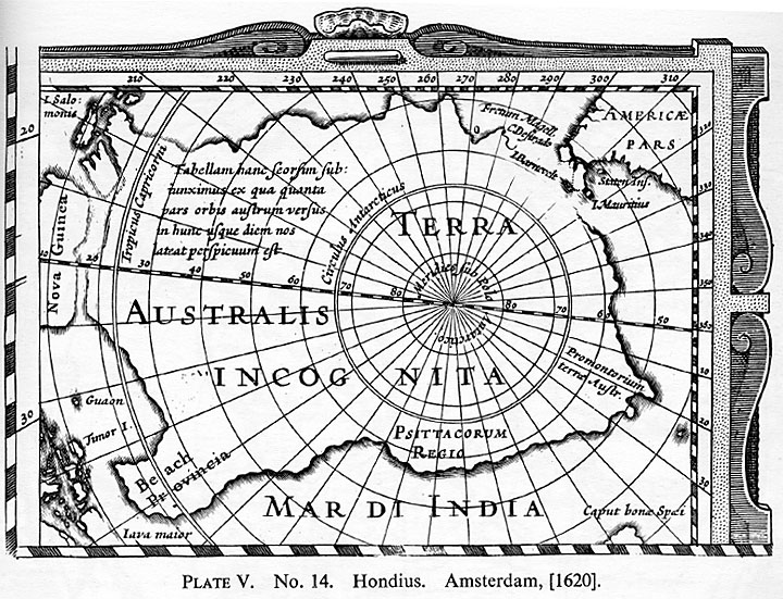
14 c1620 HONDIUS. America noviter delineata Auct. Judoco Hondio Joannes Janssonius excudit. 56-1/2 x 46 cms.
With two insets one of the North Pole and one of the South Pole. The inset of the South Pole "Terra Australis Incognita" measures 13-1/2 x 10 cms. It depicts a large unbroken continent except for a small opening off Cape Horn. Staten Land is part of the Antarctic continent.
A decorative map, it has side borders of double costume figures and top and bottom borders of vignette views of towns.
15 1620-[25] ________ Another edition, likewise undated.
A straightforward reissue of the preceding except that it is without the bottom border of towns.
16 1620-31 ________ Another edition, with a new titlepiece "America noviter delineata Auct. Henrico Hondio 1631".
The map is now without the decorative borders and the inset map of the South Pole is slightly changed, the words Cape Horn are deleted and I. Barnevelt, Staten Ins and I Mauritius inserted instead.
17 1620-41 ________ Another edition, dated 1641 with imprint of Jansson
added below title cartouche.
18 1620-[45] HONDIUS. America noviter delineata. Another edition.
The name of Hondius removed and imprint Amstelodami Excudit Joannes Janssonius only. The inset of Terra Australis Incognita remains unchanged.
19 1620-48 ________ Another edition "America noviter delineata Auct Judoco Hondio. H. Picart fecit". [c 1648].
Terra Australis Incognita unchanged.
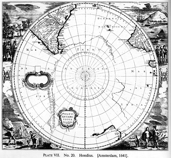
20 1641 ________ Polus Antarcticus. Henricus Hondius excudit. 49 x 43 cms.
A circular map within a square frame showing southern parts of South America and South Africa, and the West and South coasts of Australia. A Polar continent is delineated partly by island chains and partly by line. The corners are completely filled in with large vignettes of native scenes including a representation of a penguin.
Title within cartouche, and a blank cartouche presumably designed for a dedication and not used.
21 1641-[45] ________ Another issue. Joannis Janssonius excudit. [Amsterdam, 1645]. 49 x 43 cms.
A reissue of preceding except for change of name Hondius to Jansson, still with the blank cartouche.
22 1641-[50] ________ A further reissue of the preceding except that the blank cartouche is now removed, but title cartouche remains.
23 1641-[57] ________ Another edition without title. [Jansson, 1657].
In this edition both cartouches have been removed and New Zealand Van Diemans Land and the Islands of Amsterdam and Paulo added for the first time to the plate, occupying the space previously held by the title. Text on reverse.
24 1641-[80] ________ Another edition. [Amsterdam, De Wit, 1680]. A further reissue of preceding without author or imprint and without text on the back.
25 1641-1700 ________ Another issue. Amsterdam, Valk & Schenk, 1700. A repetition of the preceding with the exception that the words Apud G. Valk et P. Schenk Amstel. are added at the foot of the map.
26 1643 [HALL, J. B.] [Map of the World]. Petrus Kaerius Caelavit. [Utrecht, 1643]. 19 x 15-1/2 cms.
Hall adopted a satiric attitude towards the prevailing idea of an immense and wealthy southern land, and in his work "Mundus Alter et Idem sive Terra Australis" published in 1643, he provided the above map, with a deliberately exaggerated southern continent as large as the rest of the world combined, divided into numerous kingdoms with sarcastic names.

27 1651 SANSON, N. Mappe Monde ou Carte Generale du Monde. A Paris chez P. Mariette, 1651. Engraved Riviere. 52 x 37-1/2 cms.
The World in two hemispheres, each showing a large southern continent.
28 1652 ________ L'Hydrographie ou Description de l'Eau. A Paris Chez l'Auteur Rue de l'Arbre Secq., 1652. 53 x 38 cms.
Curiously enough Sanson in this map removes entirely the Antarctic continent from each hemisphere and the land between California and Asia. The Straits of Anian are removed from the coast of Asia to just north of the island of California.
29 1651-171[0] Mappernonde ou Description du Globe Terrestre ... Terres Arctiques et Partie des Antarctiques. Par Moullart Sanson Geographe ordin. du Roi, 171[-]. 56 x 34-1/2 cms.
A reissue of Sanson's map of 1651 but radically revised as regards America and Australia. New Zealand is now shown as part of the Antarctic continent.
30 1653 [BRIET, P. PH.] World Map. Paris Montcornet [1653]. 22 x 15 cms.
Small map showing world in two hemispheres. The eastern hemisphere has a large southern continent "Terre Australe peu cognue" with following place names: Pays des Perroquets, Lucach, Maletur and Pays de Niatz.
31 1657 SANSON, N. Les deux Poles Arctique ou Septentrionale et Antarctique ou Meridional ... jusques aux 45 Degres de Latitude Par N Sanson d'Abbeville Geographe ord. du Roy, 1657. Engraved Jean Somer. A Paris chez Pierre Mariette. 53 x 38-1/2 cms.
The Antarctic occupies the left-hand circle without any lettering except "Terre Magellanica Australe Inconnue".

32 [1670 SELLER, JOHN]. Terra Antarctica. 11-1/4 xl0 cms.
Hemispherical within double line border. Shows the southern parts of South America and South Africa and part of the East Indies.
Australia joined to Tasmania and New Zealand as a continuation of the Antarctic continent.
33 1682 ________ A Mapp of the South Pole by J. Seller. 14-1/2 x 11-1/2 cms.
This is a miniature copy of the Hondius map of Antarctica of 1640 with the same corner decorations and appears in Atlas Maritimus or a Sea Atlas, London. A. Godbid and J. Playford for John Seller ... 1682.
34 [1683 MALLET, ALLAIN MANESSON]. Continent Meridional Austral ou Antarctique. 11 x 14-1/2 cms.
In "Description de L'Univers" Vol. V published in Paris by Thierry in 1683. It was republished with German text in 1686. Shows Australia according to Tasman's discoveries and an additional coast line between Australia and South Africa and between South Africa and South America lettered "Terre Australe Inconnue".
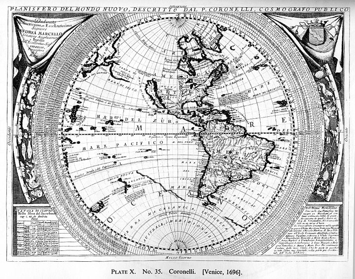
35 1696 CORONELLI, P. Planifero del Mondo Nuovo descritto dal P. Coronelli cosmografo publico. 60-1/2 x 45 cms. [Venice, 1696].
In this map Coronelli shows New Zealand as forming part of a southern continent. Giving the real discovery of Tasman for part of the west coast, he inserts an east coast running south east almost to Terra del Fuego. Here he makes a break, and further east he continues a coast line to the edge of the map marked "Costa non conosciute".
36 1696 ________ "Mare del Sud" in the same atlas "Atlante Veneto"' lie
shows New Zealand as part of a southern continent. 60-1/2 x 45 cms.
37 1696 ________ Planisfero del Mondo Vecchio. 61-1/2 x 44-1/2 cms.
38 [1700 MOLL, H.]. South Pole. 21 x 16 cms.
A reissue on a slightly larger scale of the John Seller map with New Zealand as part of Antarctic continent.
39 [1703] SELLER, JOHN. A Mapp of the South Pole by J. Seller. 14 x 11-1/2 cms. [London, 1703].
Small decorative map in form of hemisphere within rectangular frame, vignettes of natives in each corner.
Shows parts of N. Zealand and Tasmania and shadowed land between Cape Horn and Cape of Good Hope and between latter and Australia. It appeared in a miniature atlas published by Seller "New System of Geography".
40 1706 JAILLOT, H. Mappa Monde Geo Hydrographique. 64-1/2 x 45-1/2 cms.
The world in two hemispheres showing Terre Australe after N. Sanson.
41 1706-1719 ________ Mappemonde. 64-1/2 x 45-1/2 cms.
In this edition there are considerable changes e.g. California is now a peninsula instead of an island, but the representation of the Antarctic is unchanged.
42 1714 DE LISLE, GUILLAUME. Hemisphere Meridional pour voir plus distinctment les Terres Australe. A. Paris ... Juillet, 1714. Diameter 45 cms.
De Lisle with his scientific approach leaves the Polar area completely blank save for one small concession of an island "supposed to have been seen by Sir Francis Drake".

43 Reissue without imprint or date.
44 1714-[20] ________ Another edition. Amsterdam par And. & Hend. de Leth [1720]. 46-1/2 x 46 cms.
A reissue of the Paris edition but with the track of the three West India ships added, but before insertion of Cape Circumcision.
45 1714-[30] ________ Another edition. A Amsterdam Chez Jean Covens et Corneille Mortier Libraires [1730]. 45-1/2 x46 cms.
The map is now placed within a square single ruled line border and is unchanged save for the imprint.
46 1714-[40] ________ Another edition. Ou se voyent les Nouvelles Descouvertes faites en 1739 au Sud du Cap de Bonne Esperance ... sur les memoirs et sur la carte originale de M de Lozier Bouvet. Amsterdam, Jean Covens et Corneille Mortier [1740]. 52-1/2 x47 cms.
Hemispherical map within a rectangular frame with French text on left-hand side and Dutch text on right.
Shows Cap de la Circoncision 1739, Port decouvert par Franc Drak, Terre decouverte par Davis 1687, and Isle de Pasques decouverte 1722. Vignette of Cap Circoncision bottom right.
The map is not dated, but the companion map of the northern hemisphere has the imprint St. Petersbourg 13/14 Janvier 1740.
47 1714-[40] DE LISLE, GUILLAUME. Hemisphere Meridional. Amsterdam par And. & Hend. de Leth [1740]. 46 x 47 cms.
De Leth's imprint with Bouvet discoveiy added.
48 1714-[45] ________ Another edition. A Amsterdam Chez R & I Ottens Geogr [1745]. Diameter 46 cms.
A further reissue of De Lisle's map with Bouvet's discovery but without the long panel of text either side. The vignette of Cape Circumcision is retained.
49 1714-[45] ________ Another issue by Ottens, the text is now all on the right-hand side and is printed not engraved, the French text being above the Dutch text. 60-1/2 x 46 cms. including the text.
50 1714-52 ________ Another edition by Nicolas van Ewyk. Amsterdam for the author, 1752.
The map is unchanged except that it is now covered with lines to show the variation of the compass.
51 1714-[60] ________ Another edition still dated Paris 1714 but showing Bouvet's discoveries of 1739 [1760].
Though no author is given, this is probably the work of Philippe Buache for it resembles his map of 1754 making two polar continents by joining previously scattered discoveries, New Zealand being joined to Land of Gonneville and the Land of Parrots, and Cape Circumcision with Port of Sir Francis Drake.
52 1714-82 ________ Another edition. Nouvellement revu corrige et augumente des Niles Descouvertes du Capitaine Cook avec les Routes de ce celebre Navigateur. Par Dezauche successor des Srs De Lisle et Buache 1782. Diameter 45 cms.
Showing the tracks of Cook and the delineation of Australia and New Zealand altered to conform with his discoveries.
53 1718-30 CHATELAIN, H. A. Mappemonde ou Description Generale du Globe Terrestre. Amsterdam. 44 x 33 cms.
In this particular map of the world Chatelain gives an extraordinary version of a southern continent. Lettered "Terres Australes Inconnues" he shows a continuous coast along the base of his map actually joined to Australia at Nuyts Land.
54 1718-30 ________ In the same atlas.
As if dissatisfied, in his "Mappe-Monde pour connoistre les progres & conquestes ... des Provinces Unis" 46 x 33-1/2 cms., he shows a Terre Australe Inconnue with a gap opposite Magellan,and separated from Australia on the right.
55 1718-30 ________ In the same atlas.
In his third World Map "Nouveaux Mappemonde ou Globe Terrestre" he leaves his southern oceans quite free of land, except for a tiny island discovered by Sir Francis Drake and a small "Terre de Vue" south west of the Cape of Good Hope.
All three maps were issued in the same Atlas Historique ou Nouvelle Introduction a L'Histoire a la Chronologie et a la Geographie Ancienne & Moderne published in 7 vols in Amsterdam. The atlas was reissued 1720-39 and 1732-39.

56 (1720) PRICE, C. South America Corrected from the Observations communicated to the Royal Societies of London and Paris by C. Price sold by T. Brandreth and G. Wildey (dedication to Edmund Halley). 63 x 89 cms.
This map is of interest as showing the voyage of La Roche with two small landfalls below the Falkland Is. bearing the legend "the Streights of La Roche discovered in 1675 La Roche I. incognita".
"The sea in these parts abounds in two sorts of animals of the middle species between a bird and a fish having necks like swans and swimming with their whole bodyes always under water only putting up their long necks for air". To the right is an extraordinary vignette of snow houses with the legend "into this latitude came Americus Vespucio in 1502 after he had left the coast of Brasill having run 500 leagues to the south east".

57 [1720] MOLL, HERMAN. A New and Correct Map of the World, laid down according to the newest discoveries and from the most exact observations. 97 x 56-1/2 cms.
Moll leaves his southern oceans completely blank but has this legend within the Antarctic circle, "The inhabitants if any there be who dwell within this circle have continual night when ye sun is in ye Tropick of Cancer and continual Day when in ye Tropick of Capricorn."
58 1729 ________ A Map of Chili Patagonia La Plata and ye South Part of Brasil. (London), 1729. 20-1/2 x 27-1/2 cms.
Of slight antarctic interest showing "Srt. de la Roche and Unknown Land," also the track of Capts. Rogers & Dampier, Lat. 61.53, A.D. 1709.
59 1734-5 DU SAUZET, HENRI. Terres Antarctiques. Amsterdam, Du Sauzet, 1734.
60 Reissue 1738.
61 1739 BUACHE, PHILIPPE. Carte des Terres Australes comprises entre le Tropique du Capricorne et le Pole Antarctique. Engraved Delahaye. Paris, 1739. 31 x 23-1/2 cms.
Two small land falls are shown outside the Polar circle "Port discovered so it is said by Sir Francis Drake, 1st Oct. 1578," and "Cap de la Circoncision discovered 1 January 1739."
Shows the tracks of Magellan, Le Maire, Halley, Dampier, Tasman and the L'Aigle.
With inset bottom right "Plan et Vue des Terres du Cap de la Circoncision."
62 1739-54 ________ Another edition Augumentee de diverses vues, Physiques &c. 1754. Engraved Delahaye. Still with imprint Paris 1739. 31 x 24 cms.
In this issue one larger and one smaller land mass are inserted round the Pole. New Zealand now forms part of this Antarctic land and is linked up with Terre de Gonneville and Terre des Perroquets. The smaller land mass joins Cape Circumcision, the Landfall of Vespucci and the Port of Sir Francis Drake. An egress is shown either side with the remark "Capts. Davis and Sharp saw Ice Islands in these passages 1687." The track of the Spanish ship the Lion 1736 is added to the plate.

63 1739-63 BUACHE, PHILIPPE. Chart of the Antarctic Polar Circle with the Countries adjoining according to the New Hypothesis of M. Buache. An English copy of the preceding on a smaller scale from the Gents Mag. 1763. 22 x 19 cms.
64 [1740] DE LISLE, G. MAPPEMONDE par M. de Lisle nouvellement corrigee apres les derniers Descouvertes, faite par l'Academie de Petersbourgh. Amsterdam Covens & Mortier. 64 x 49-1/2 cms.
This world map has 4 inset hemispheres. Two of these are southern hemispheres each showing a large though not continuous Antarctic land round the South Pole.
This representation is inserted by the Dutch publishers and had nothing to do with the great De Lisle, being rather based on the ancient form of the elder Sanson of a century earlier.
On the main map itself Bouvet's Discovery of 1739 is shown, the old Terre de Vue of the Spaniards, Vespucci's furthest South, Ice seen by M. Halley, and Sir Francis Drake's Island. This is last placed right on the Antarctic Circle.
65 [1740] Tabula Geographica Hemisphaeri Australis. Acad. Reg. Scient. et Eleg. Litt. Boruss. descripta. I C R delin. Diameter 30-1/2 cms.
The Southern hemisphere published by the Royal Academy of Science and Literature of Prussia. Shows Cap de la Circoncision and Drakes Harbour.

66 [1740-55] Another edition, revised.
A curious map published by the Royal Academy of Prussia showing an immense hypothetical antarctic continent joining up the discoveries of Quiros 1605, Tasman's New Zealand and Cap de la Circoncision. Large mountain chains traverse this continent from side to side. In the outer circle New Guinea, Australia and Tasmania are shown joined together.
67 1740 WEIGEL, C. Facies Poli Antarctici ex recentissimis itinerariis descripta a Christophoro Weigelio. 35 x 32 cms.
A circular map within a square frame depicting Magellanica and a large polar continent blank save for the words "Terra Incognita Australis." This is in effect a copy of Sanson's map of 1657.
68 1744-57 BUACHE, PHILIPPE. Carte Physique de la Grande Mer ci-devant nommee Mer du Sud ou Pacifique ... avec la representation de ce que l'on conjecture Sur la Mer Glaciale Antarctique. Dressée et Presentée a l'Acad des Sc. le 5 Sept. 1744. Publiée ... 4 Sept. 1754. Grave par Desbruslins Pere 1757. 40 x 31 cms.
With inset hemisphere bottom centre "Carte de la Mer Glaciale Antarctique." In this map Buache inserts two land masses with a central open sea round the South Pole. New Zealand is shown half in half out, breaking the hemisphere. It is unconnected with Polar Continent. The larger of the two masses round the Pole is marked Elevated Land according to Tasman corresponding to the Cordilleras. The smaller land mass joins Cape Circumcision and Port of Francis Drake.
69 1746 HOMANN, HEIRS. Planiglobi Terrestris. Engraved S. Dom, Nurnberg, 1746. 52 x 44 cms.
Shows the world in two hemispheres by Prof. Has, drawn by M. G. M. Lowitz. It contains four smaller inset hemispheres one being "Hemisphere Polair Antarctique." This leaves the polar seas open but shows the discovery of Bouvet (C. Circoncision), Terra Australis and I. Ignis and one landfall un-named off the coast of Chili. This small hemisphere has a diameter of 13 cms.
70 1760 BUACHE, P. Hemisphere Occidental, dresse en 1720 pour l'usage particulier du Roy sur les Observationes Astronomiques et Geographiques ... Par Guillaume de Lisle ... Revu et augmente par Ph. Buache en 1760. Diameter 48 cms.
Shows the tracks of the St. Louis 1708, the Eagle and Marie in 1738, and the Spanish ship Lion in 1756, and at the base of the hemisphere two large land masses "Terres Australis Antarctiques soupconnees."
New Zealand is shown as part of this antarctic continent. The original map of De Lisle was free of these blemishes.

71 1764 DENIS, LOUIS. Mappe Monde physique politique et mathematique ... extrait des cartes des Srs de Cassini, D'Anville, De Lisle, Bellin et autres, Geographes. Par Louis Denis a Paris, 1764. 123 x 61-1/2 cms.
An extraordinary map with the wildest geography, showing Russian Discoveries in the N.W. in 1741, the Sea of the West, Chinese America, submarine mountains, Australia Terre du Saint Esprit and Tasmania as one continent, and an enormous Terres Antarctiques with inlets to Polar Sea.
New Zealand is part of this Antarctic continent.
72 1773 VAUGONDY, SIEUR DE. Hemisphere Australe ou Antarctique projette sur un Horizon dont le zenith est situe a 140 degres de longit. orient. de L'Isle de Fer ... Pub. sous l'approbation de l'Academie Royal des Sciences du 24 Mars 1773. Engraved E. Dussy. 61-1/2 x 64-1/2 cms.
Shows the tracks of Tasman, Cook, Wallis, Bougainville and Cartaret and the discoveries of Kerguelen and Bouvet.
73 1773-77 ________ Another edition. Augmente en 1776 des descouvertes faites par le Capit. Cook en 1773, 74, et 75.
A reissue of the preceding with the extra tracks of Cook and Furneaux added and a long note engraved at foot, " Observations de 1777."
74 1773 VAUGONDY, SIEUR DE. An English edition was issued with title "A Southern or Antarctic Hemisphere."
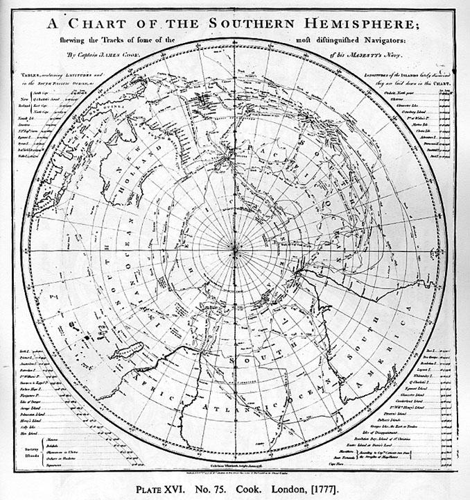
75 1777 COOK, CAPT. JAMES. A Chart of the Southern Hemisphere showing the Tracks of some of the most distinguished Navigators ... Gulielmus Whitchurch sculpsit Anno 1776. Pub. Feb 1 by Wm. Strahan ... & Thos Cadell. 54 x 55-1/2 cms.
Issued in Cook's Second Voyage towards the South Pole. A hemisphere within a plain rectangular frame. It depicts the whole of Australia, New Zealand and a large part of the E. Indies, Africa and S. America and marks the tracks of Mendana 1595, Quiros 1606, Le Maire & Schouten 1616, Tasman 1642, Roggewein 1722, Bouvet 1739, Byron 1765, Wallis & Cartaret 1767, Bougainville 1768, Surville 1769 and Cook & Furneaux 1773-4.
It marks "Land said to be discovered by M. de Kerguelen in Feb 1772," "Desert Isles said to be discovered by M. Marion in Jan 1772," Isle of Georgia, Sandwich Land" Feb 3 1775 Candlemas Isles," and the icefields that barred his passage at different points.
76 1777 ________ Carte de L'Hemisphere Austral. Benard direxit. 53-1/2 x 53 cms.
An exact copy of Cook's Chart translated into French.
77 1777 ________ Another edition. Hemisphere Austral ou Antarctique projette sur un horizon dont le Zenith est situee a 140 degres de longit. orient. de L'Isle de Fer et a 66d 32' de latit. australe ... par le Sr. de Vaugondy Geographe ord. du Roy ... Pub. sous l'approbation de l'Academie royal des Sciences de 24 Mars 1773 et augmente en 1776 des descouvertes faites par le Capit Cook en 1773, 74 et 1775. 62 x 64-1/2 cms.
Originally published before Cook's Voyage, this map shows earlier discoveries that were not verified by Cook and do not show on his map, for example, Bouvet's discovery of Cape Circoncision. " Floating Ice seen by M. Frezier 1714." "Ice seen by Davis 1680," &c.
78 1779 ZATTA, ANTONIO. Emisfero Terrestre Meridionale. Tagliato su l'Equatore G. Zuliani in G. Pitteri scr. Venezia MDCCLXXIX Presso Antonio Zatta. 40-1/2 x 31-1/2 cms.
Circular map within a square. Shows the tracks of Capts. Cook and Vancouver, Cape Circumcision, Bay of Uccello discovered January 1774.
79 [1780] LIRELLI, SALVADOR. Le Globe Terrestre. 69-1/2 x 58-1/2 cms.
An unusual map with a long title dedication to the King of Sardinia at the top of the map, below two hemispheres and below them the world on a plane projection. The routes of Capt. James Cook are shown on all three. 1776-90. Thick ice mountains are shown all round the Polar circle.
80 1785 CLOULT, L'ABBE. Carte Generale de la Terre ou Mappemonde avec les quatres Principaux Sistemes corrigee et augmentee d'apres les Nouvelles Observations de Mrs. de l'accademie Rle. des Sciences. Par Mr. L'Abbe Clouet A Paris chez Mondhare 1785. 88 x 65 cms.
Title in French and Spanish. Another extraordinary French production showing the world in two hemispheres each supported by a figure of Atlas. It mixes actual discovery with pure fantasy in the Buache-Denis tradition. It depicts the Russian Discoveries in the N.W. in 1741 but also the Lake of Valasco and the Sea of the West and the Lac de Fonte. It also shows the tracks of Cook, Bougainville, Furneaux and earlier navigators. Australia, New Zealand and the Land of the Holy Spirit are all joined together, and New Zealand forms part of a large polar continent.

81 [1787] MOITHEY. Le Globe Terrestre vu en convexe par les deux Poles l'Equator servant d'horizon. Moithey Ing. del et sculp Herault Scrip [Paris Philippe 1787]. 41 x 24 cms.
Showing a Northern and Southern hemisphere with title within cartouche between.
Based on the Buache map of 1754 with two polar masses divided by a central polar sea. New Zealand as part of this Antarctic continent.
82 1787 ________ "Indication Nautique des principaux espaies de l'Ocean." Paris 1787. 38-1/2 x 25 cms.
Similar to the preceding.
83 1787 BONNE AND DESMARET. Mappernonde sur le plan de l'equator Hemisphere Meridionale. Engraved Andre. 34-1/2 x 23 cms.
Shows I. de la Georgie, Rochers de Clarke, I. de le Chandeleur, Terre de Sandwich, I. de le Desolation and I. de Drak.
Issued in Atlas Encyclopedic. Paris 1787.
84 1790 FADEN, W. Southern Hemisphere, Northern Hemisphere engraved by William Faden. Each 34-1/2 cms. diameter.
Showing the tracks of Capt. Cook with Georgia and Sandwich Land.
85 [1794] A General Chart exhibiting the Discoveries made by Capt. James Cook in this and his two preceding voyages with the Tracks of the Ships under his command. By Lieut. Roberts of His Majesty's Royal Navy. 90 x 53-1/2 cms.
A popular map of the World on Mercator's projection showing the tracks of Cook's three voyages 1768-71, 1772-75, 1776-80.
86 1802 FADEN, WILLIAM. Southern Hemisphere. London, W. Faden, May 1st 1802. 57 cms.
Shows New Georgia, Sandwich Land, Isles Marion, Isles Crozet, Kerguelen Land.
87 1802 LAURIE, ROBERT AND JAMES WHITTLE. South Pole, from the Tropic of Capricorn with the addition of all the new discoveries.
88 1812 PINKERTON. Southern Hemisphere. Drawn under the direction of Mr. Pinkerton by L. Hebert, engraved Neele, London Pub. 1812 by Cadell and Davies. Diameter 50-1/2 cms.
Shows Kerguelen Land, Crozets Islands, Marions Island, Sandwich Land and South Georgia.
89 1814 THOMSON. Southern Hemisphere engraved Kirkwood. Drawn and Engraved for Thomson's New General Atlas. 12 August 1814. Diameter 50-1/4 cms.
The Polar Region marked Icy Sea Antarctica and engraved with close horizontal tines with legend "Cook's Highest latitude was 71°10 from thence Ice is supposed to extend all round the Pole."
90 1816 ________ Southern Hemisphere projected on the plane of the horizon of London. By Geo. Buchanan. Engraved J. &G. Menzies. Diameter 50-1/2 cms.
In this edition the tracks of Capt. Cook are added. The Antarctic is heavily shaded, bears no names but has the legend "Firm fields and vast mountains of ice, 1 Feb. 1774, 71.11 Highest south lat. of Capt. Cook."
91 1820 S. Hemisphere engraved Neele. Pub. Nov 1 1820 by Pinnock & Maunder. Diameter 22-1/2 cms.
This small map is of interest as it shows Diego Atvarez as well as Kerguelens Land, Is. Crozet and Prince Edward Is., Georgia, Sandwich Land and Isle of Georgia.
92 [1820 Rossi] Regioni Polari paragonate Secondo gli ultimo Viaggi. Engraved Caniani. Milano presso Batelli e Fanfani. 39-1/2 x 21 cms.
Shows a northern and southern hemisphere, in the latter the track of Capt. Cook 1773 and 1774 and of Bouvet with ice formations at points of contact.
93 1820 Karta Yozhnago Polushariya. 24 x2 4 ins. St. Petersburg 1821.
To illustrate the route of Bellinghausen.
94 1821 WOODBRIDGE, WILLIAM C. The World. 12-1/4 x 9-3/4 cms. [Hartford, Conn. 1821].
This unpretentious map is the earliest to show and name the discoveries of Nathaniel Palmer of Stonington, Connecticut, a Captain of an American sealer who surveyed the South Shetland Islands and after whom part of Antarctica was named "Palmers Land."
The map appeared in Woodbridge's School Atlas to accompany Rudiments of Geography published at Hartford in 1821.
95 1824 Admiralty Chart. A general chart of South America from a drawing by A. B. Becher, R.N., combined with the best English and Spanish Surveys. 62 x 76-1/2 cms. London Hydrographical Office, November 4 1824. Engraved J. Walker.
Covers an area from Philadelphia to Cape Horn. Shows Southern Georgia, Sandwich Land, Powells Group, South Shetland and Palmers Land.
96 1831 S.D.U.K. SOCIETY FOR THE DIFFUSION OF USEFULL KNOWLEDGE. Circumjacent the South Pole. Engraved by J. & C. Walker. Published by Baldwin & Craddock, June 1831. 28 x 27 cms.
Shows Marion & Crozets Isles, Kerguelens Land or Isle of Desolation, Southern Georgia, South Shetland & New Orkneys and Islands of St. Peter & Alexander discovered by Bellinghausen 1822.
97 1831-42 ________ SOCIETY FOR THE DIFFUSION OF USEFULL KNOWLEDGE. Another edition. London, Chas. Knight & Co. [1842]. 27-1/2 x 27-1/2 cms.
To this edition have been added Graham Land, Enderby Land, Sabrina Land, La Terre Adele, Emerald Is. and Balleny Is.
98 1831-52 ________ SOCIETY FOR THE DIFFUSION OF USEFULL KNOWLEDGE.
Another edition. London Charles Knight 1852. 27 x 27-1/2 cms.
Further editions Victoria Land 1841, and Ice Barrier discovered by Lieut. Wilkes, U.S.N.
99 1833 ROYAL GEOGRAPHICAL SOCIETY. Part of the Southern Hemisphere shewing recent discoveries. W. Day, Printer. Published for the Journal of the Royal Geographical Society by John Murray 1833. C. Bradbury lith. Diameter 26 cms.
Showing the tracks of Cook 1774, Weddell 1823 and Biscoe 1831-2, Enderbys Land and Grahams Land.
100 1836 WYLD, JAMES. Southern Hemisphere. Diameter 58 cms.
Shows Kerguelens Land, Isles Crozet, Isles Marion, Sandwich Land, New Georgia and South Shetland.
101 1838 S.D.U.K. South America Sheet V Patagonia. Engraved J. & C. Walker. Published by the Society for the Diffusion of Useful Knowledge ... Apl. 2nd 1838. 39-1/2 x 32 cms.
With two insets one small "Isle of Georgia," the other "The South Shetland and Orkneys." This shows the South Shetlands in some detail with mountains named in Grahamland and Trinity or Palmer Land.
102 Reissue undated by Charles Knight, and in 1852 and 1853 by George Cox, without any change in the S. Shetlands.
103 1842 HYDRO OFFICE. ADMIRALTY. The South Polar Chart. June 1839[42]. Diameter 62 cms.
Shows Cook's track of 1773-4; Alexander and Peter Islands, Bellinghausen 1821; Enderby Land, Weddel 1823; Cape Possession, Foster 1829; Graham Land, Biscoe 1832; Kemp Land, Biscoe 1833; Adele Land and Terre Louis Philippe, Durville 1838; Erebus Gulf, Balleny 1839; South Victoria and Ross track of 1841-2.
104 1843 TANNER, HENRY SCHENK. Oceana or Pacific Ocean. With inset of Wilkes Discoveries.
105 1846 MITCHELL, SAMUEL AUGUSTUS. Oceana or Pacific Ocean. With inset of Wilkes Discoveries.
Reissued 1847, 1848.
106 [1849] MEYER, J. Erd-Karte in der Globular Projektion. 36 x 29-1/2 cms.
Shows Enderby Island, Kemp L., Wilkes Land 1840, Sabine I. and Adelie. Balleny Is. 1839, South Shetland, Trinity L., and Weddel 1823.
107 [1849] ________ From the same atlas Meyers Hand Atlass "Welt Charte," in Mercators Projektion 1849. 24-1/2 x 21 cms.
Shows following discoveries Biscoe Feb 1831, Enderby Land, Kemp Land, Sabine, Adelie, Balleny, Wilkes Land, Peter Is. and Trinity Land.