A LETTER FROM THE ANTARCTIC

The title page from A Letter from the Antarctic.
1. Franklin Island. January 27, 1841. Lat . 76° 8' S. long. 168° 12' E.Works by Davis have appeared in Christie's sales in London:
2. New Year's Day, 1842. Lat. 6° 32' S. long. 156° 28' W.
3. Possession Island, Victoria Land. January 11, 1842. Lat . 71° 56' S. long. 171° 7' E.
4. Watering in the Pack, 1842. 5. Cape Davis. Lat . 70° 32' S. long. 166° 6' E.
6. Cape Crozier.
10 April 1997, Lot 95JOHN E. DAVIS (active 1839-43)17 September 1998, Lot 178
The Erebus and Terror in the Ross Sea
watercolour, unframed
7-3/8 x 11-3/8 in (18.8 x 28.9cm.)
Davis was Second Master on Commander Crozier's Terror and a number of his drawings (the first ever of the Antarctic continent) were used by Ross to illustrate his A Voyage of Discovery and Research in the Southern and Antarctic Regions during the years 1839-43 published in two volumes in London in 1847. James Clark Ross had reached the northern magnetic Pole in 1831 and was charged by the Government, following the recommendation of the British Association for the Advancement of Science and the Royal Society, to lead an expedition to investigate terrestrial magnetism in the southern latitudes.
The expedition was the first British exploration of the southern latitudes since Cook's skirting of the Antarctic circle in 1773-4 and the sealer Weddell's furthest south of 74°15'S in 1823. Bellinghausen had probably been the first to sight the Antarctic continent in January 1820 and Dumont d'Urville then discovered Adelie Land and Claire Coast. Their work towards the discovery of an Antarctic landmass was consolidated by James Clark Ross who penetrated the pack ice in January 1841 sailing into the clear water of the uriknown Ross Sea and sighting snow-covered land on 11 January, thereby becoming the first to discover a sea route to the continent. McCormick on the Erebus saw and named an active Volcano (Mt Erebus) and Ross was the first to see and chart the South Polar Barrier which he named Victoria Barrier and which was later named the Ross Ice Barrier. He made two further navigations of the Ross Sea and Weddell Sea before returning to England in 1843.
£3,000-5,000
US$5, 000-8,200
Result: £9,775 including the buyer's premium. This painting was later offered at a Christie's sale (7261) held on 27 September 2006, Lot 154. It did not sell.
CAPTAIN JOHN EDWARD DAVIS, R.N. (1815-1877)17 September 1999, Lot 177
H.M. Ships Erebus and Terror, January 20th 1842, in Latitude 66°.37' South, Longitude 159°.48' West
signed and dated 'J.E. Davis 1842' (lower left), inscribed as titled beneath the subject.
black, white and red chalks on brown paper 7-1/4 x 10-1/8in. (18.4 x 25.8cm.) ENGRAVED: by T. Picken in Capt. Sir J.C. Ross, A Voyage of Discovery and Research in the Southern and Antarctic Regions, during the years 1839-43, London, 1847, I, facing p. 169.
Davis was Second Master on Commander Crozier's Terror and a number of his drawings (probably the first ever of the Antarctic continent) were used by Ross to illustrate his official account of his voyage published in two volumes in London in 1847. James Clark Ross had reached the northern magnetic Pole in 1831 and was charged by the Government, following the recommendation of the British Association for the Advancement of Science and the Royal Society, to lead an expedition to investigate terrestrial magnetism in the southern latitudes. The expedition was the first British exploration of the southern latitudes since Cook's skirting of the Antarctic circle in 1773-4 and the sealer Weddell's furthest south of 74° 15'S in 1823. Bellinghausen had probably been the first to sight the Antarctic continent in January 1820 and Dumont d'Urville then discovered Adelie Land and Claire Coast. Their work towards the discovery of an Antarctic landmass was consolidated by James Clark Ross who penetrated the pack ice in January 1841 sailing into the clear water of the unknown Ross Sea and sighting snow-covered land on 11 January, thereby becoming the first to discover a sea route to the continent. McCormick on the Erebus saw and named an active volcano (Mt. Erebus) and Ross was the first to see and chart the South Polar Barrier which he named Victoria Barrier and which was later named the Ross Ice Barrier. He made two further navigations of the Ross Sea and Weddell Sea before returning to England in 1843.
The present drawing by Davis records an incident on their second season in the Ross Sea, when a storm badly damaged both the Erebus and Terror, the latter's rudder being broken to pieces by the ice and having to be replaced by the spare rudder: 'On the morning of the 20th it blew a heavy gale of wind; there we were in the midst of very heavy ice with a very heavy swell on. The ship at times striking hard, it was very difficult to pass clear of the largest pieces which threatened at times to crush us ... we were afraid for our bowsprit, it being so low, but we experienced a greater loss in our rudder which was broken and rendered useless at ten in the forenoon. A tongue of ice got under it and completely ground it round, splitting it all the way up .. ' (Capt. J.E. Davis, R.N., A Letter from the Antarctic, London, 1901, pp. 17-18, with a sketch after the present drawing illustrated p. 20).
The Erebus and Terror weathered the storm and on 4 February the ships continued southwards. The ships found greater fame when they were taken by Franklin to the Arctic in 1845 (see lot 143), never to be seen again.
In a frame inscribed 'THIS FRAME IS MADE FROM THE REMAINS OF THE RUDDER OF THE TERROR"
£10,000-15,000
US$17,000-25,000
Result: £11,500 including the buyer's premium. This painting was later offered at a Christie's sale (7261) held on 27 September 2006, Lot 155. It sold for £12,000 including the buyer's premium.
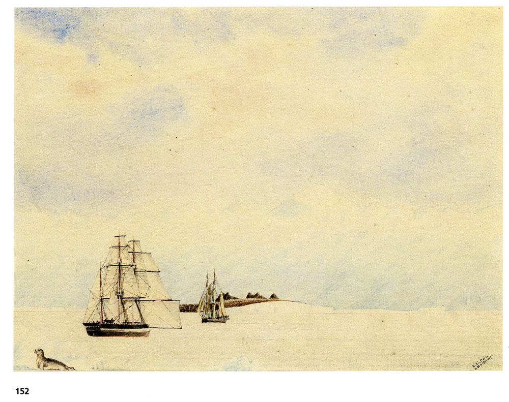
CAPTAIN JOHN EDWARD DAVIS, R.N. (1815-1877)27 September 2006, Lot 152
Cape Lockyer, discovered by H.M. Ships Erebus and Terror, January 7th 1843 titled on the original detached label.
watercolour
6-3/4 x 8-15/16in. (17.2 x 22.7cm.)
Davis was Second Master on Commander Crozier's Terror and a number of his drawings (probably the first ever of the Antarctic continent) were used by Ross to illustrate his official account of the voyage published in two volumes in London in 1847.
James Clark Ross had reached the northern magnetic Pole in 1831 and was charged by the Government, following the recommendation of the British Association for the Advancement of Science and the Royal Society, to lead an expedition to investigate terrestrial magnetism in the southern latitudes. The expedition was the first British exploration of the southern latitudes since Cook's skirting of the Antarctic circle in 1773-4 and the sealer Weddell's furthest south of 74°15'S in 1823. Bellinghausen had probably been the first to sight the Antarctic continent in January 1820 and Dumont D'Urville then discovered Adelie Land and Claire Coast. Their work towards the discovery of an Antarctic landmass was consolidated by James Clark Ross who penetrated the pack ice in January 1841 sailing into the clear water of the unknown Ross Sea and sighting snow-covered land on 11 January, thereby becoming the first to discover a sea route to the continent. McCormick on the Erebus saw and named an active volcano (Mt. Erebus) and Ross was the first to see and chart the South Polar Barrier which he named Victoria Barrier and which was later named the Ross Ice Barrier. He made two further navigations of the Ross Sea and Wedell Sea before returning to England in 1843.
'Jan. 7. 1843 ... As we advanced to the southward, two high rugged bluff capes at a great distance appeared, bearing w.s.w. (true); the nearest of them I named, at the request of Captain Crozier, after his friend Captain Nicholas Lockyer, R.N.C.B. (Capt. Sir J.C. Ross, A Voyage of Discovery and Research in the southern and Antarctic Regions, during the years 1839-43, London, 1847, II, p.346).
For Davis's own account see his A Letter from the Antarctic, London, 1901 (illustrated with own sketches).
For further works by Davis on the voyage, see Christie's, 10 April 1997, lot 95 and 17 September, 1998, lot 178.
£5,000-7,000
US$8,100-11,000 €7,600-11,000
Result: £5,750 including the buyer's premium.
CAPTAIN JOHN EDWARD DAVIS, RN (1815-1877)27 September 2006, Lot 153
Mount Sabine in Latitude 71° South and Longitude 169°. 00' East - West 40 miles—Discovered by H.M. Ships Erebus and Terror Jany 11th 1841 signed 'J.E.Davis / H.M.S. Terror: (lower right), inscribed as titled on the mount and inscribed 'To Mrs Sabine with Captain Crozier's Compliments' on the reverse
watercolour on paper
7-1/8 x 9-1/2 in (18.1 x 24.2cm.)
£4,000-6,000
US$7,600-11,000 €6,000-8,900
PROVENANCE:
Mrs Sabine (Elizabeth Juliana Leeves 1807-1879). The Ross family and by descent to the present owner.
The mountain named for Sir Edward Sabine (1788-1883), army officer and physicist who sailed on Ross and Parry's Arctic voyages in 1818-21. 'Janry the 11th at two o'clock on Monday Morning, we discovered Victoria Land the Morning was beautiful and clear. at 7 o'clock in the afternoon we were under the Lee of the land sounded 250 fathoms of water - not a cloud to be seen in the firmament, but what lingered on the mountains - Large floating islands of ice in all directions. Hills vallies and Low Land all covered with snow. The snow topd. mountains Majestically Rising above the Clouds. The Pinguins Gamboling in the water the reflection of the Sun and the Brilliancy of the firmament Made the Rare Sight an interesting View. That night we stood off from the land, we did not Loose sight of it for the Sun was high above the Horizon at midnight as it would be in England on christmas day. While we were in these distant Regions we had no night I mean dark' (Cornelius Sullivan, blacksmith on Erebus, quoted in M.J.Ross, Ross in the Antarctic, Whitby, 1982, pp.84-5) Result: £4,800 including the buyer's premium.
CAPTAIN JOHN EDWARD DAVIS, RN (1815-1877)
Mount Sabine in Latitude 71° 50' South and Longitude 169° 0' East - West 40 miles—Discovered by H.M Ships Erebus and Terror Jaruary 11th 1841
inscribed as titled and with inscription 'For Mrs Sabine with Captain Crozier's Compliments' on the reverse
watercolour on paper
7 x 9-1/2 in. (17.8 x 24.2cm)
£4,000-6,000
US$7,5600-11,000. €6,000-8,000
PROVENANCE:
Mrs Sabine (Elizabeth Juliana Leeves (1807-1879).
The Ross family and thence by descent to the present owner. Result: £4,800 including the buyer's premium.
The entry for A Letter from the Antarctic in Michael Rosove's monumental Antarctica, 1772-1922; Freestanding Publications through 1999
For a pdf copy of A Letter from the Antarctic, click here.
HOME